Skip to content

Our service

TARGETING SERVICE

Mineural offers a targeting service for mineral exploration. We work at all scales
(property, district, country) and can target any mineral commodity. Our service is based
on a revolutionary technology called IRIS (Intelligent Resource Identification System).

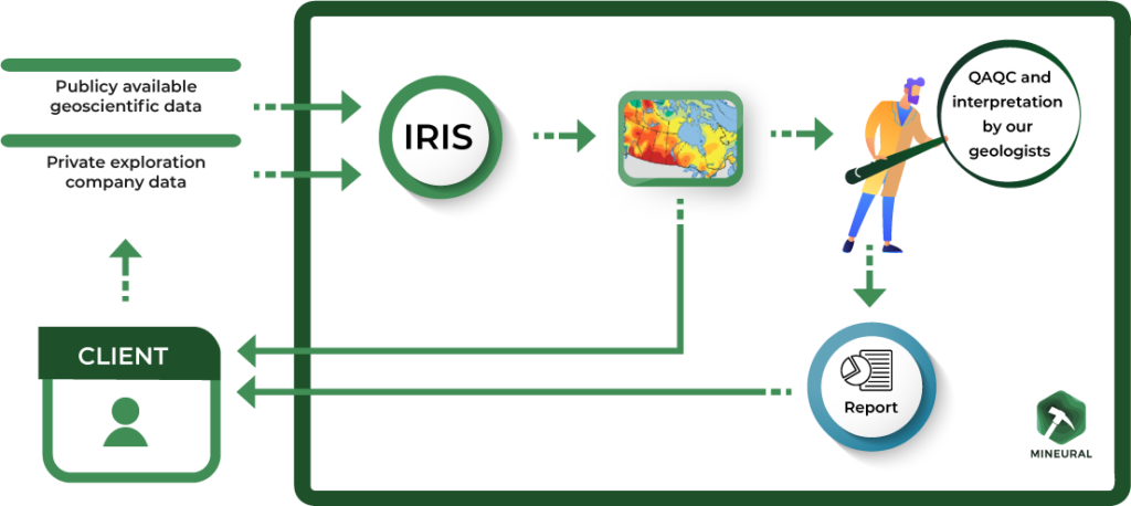
We complement your exploration data with publicly available data. We then process it in
our proprietary IRIS technology. Once the results are in, we send them directly to you, so you can make the rapid decisions needed for your operations. Our geologists then write a detailed report explaining and analyzing the results, incorporating their exploration expertise, which you receive a few weeks later.

IRIS - A technological breakthrough for exploration :

The major hurdle to the application of AI to geology stems from the fact that current AI- based approaches are unable to simultaneously take into account data of different types, making the development of high-performance models impossible. Mineural has solved this problem by developing IRIS, the only AI technology applied to geology capable of a holistic approach. This means that we process all types of exploration data (geophysical, geological, geochemical, etc.) together, in a single neural network. Just as a geologist interprets different types of data in the same set to explain a deposit or showing, IRIS autonomously develops a model that takes into account all types of data and tends to explain all deposits or showings in the study area. In this unique model, all
data are considered together, enabling IRIS to learn the interactions and correlations between them when training the neural network, which is only possible thanks to our proprietary toolset.  Other current approaches, when using AI, do so on one type of data at a time. The results obtained with each data type are then summed or weighte to obtain a map that represents them all.

Other AI based solutions:

Why use IRIS and Mineural services?

1 - Performances

Compared with standard approaches, targets obtained with IRIS are 70-95% smaller, averaging 85-90%. High-potential areas and known indices are highly correlated. In fact, the areas targeted by IRIS contain the majority of showings and deposits in the study area, which is not the case with standard approaches.

2 - Reduced discovery time

The speed of IRIS generation means that the model and maps can be quickly updated
as new data is added. This makes multiple iterations of targeting during a campaign
possible. The smaller, better-defined targets obtained with IRIS allow you to focus
exploration efforts on the highest-potential areas in your area of interest, enabling faster
discoveries on a district or large property scale.

​3 - Reduced exploration expenditure

Smaller targets and better prioritization of areas to explore greatly reduce the time
needed to study a “grassroots” property to define its potential. Exploration campaigns,
especially helicopter-borne ones, can cost from $10K to $20K per day. By using our
service, you can reduce the duration of your campaigns by more than 50% and save
significant capital that you can allocate to other projects or other exploration actions.

​4 - A cost-effective technique

The price of our services is low, considering the product obtained and the capital saved by using it. For the cost of a few days’ exploration, you improve your discovery potential while saving on your current campaigns.

5 - Staying one step ahead

AI has been used for over a decade in fields such as pharmaceuticals, aviation and so on. In recent years, it has begun to appear in mining and exploration. We offer you the best AI available at a reasonable cost. Adopt IRIS and stay one step ahead.

Main use cases :

Target generation for claim acquisition on a geological province or district scale.

Target generation at the scale of one or more grassroots properties for initial prospecting.

Target generation for the discovery of new showings on a property at an advanced stage of exploration.

Prioritization of targets and optimization of prospecting campaigns.

Jurisdiction-wide mineral potential inventory for public organizations.

Generation of 3D* drilling targets for resource expansion or discovery of new mineralized zones.

*This product is currently under development, and Mineural is seeking client-partners to
assist in the development process. We offer customers the opportunity to become
partners in this project at a very attractive cost. We will generate targets for you as we
develop the technology, which means you will have access to the technology and the
results it delivers about a year before the rest of the market. Contact us for more
information.